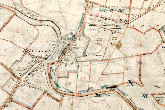
James Boylan was my maternal great great grandfather. He was rumoured to be 100 years old when he died but it turns out that he was "only" 90 (1806-1897). He was born in Kilcullen and worked as a tailor. His son (also James; 1841-1902) was also a tailor so presumably he took over the family business. Father and son died within 5 years of each other. Both lived in Kilcullen all their lives ... but where?
There are a variety of sources that help locate exactly where they lived. These are summarised below and digital images of the original records are included.
1852 - House Book from NAI website shows that James Boylan senior (then aged 46) lived in a large house (worth £4 2s 6d) on Plot 10. He also had a stable, 2 barns & a cow house.

1853 - Griffith's Primary Valuation from the AskAboutIreland website
- Plot 10 = 2A 1R 0P (i.e. 2 acres, 1 rood & zero perches ... 40 perches in a rood, and 4 roods in an acre)
- The tenant has to be James Boylan senior (as junior is only 12 years old)


1860 - 1st Cancelled Book (photographed in person at the Valuation Office)
Plot 10 = 2A 1R 0P (James Boylan senior)
Plot 9 = 1A 3R 12P (James senior seems to have acquired this plot of land shortly after 1853, then it changed hands to Mathew Mallery (Malloy?), and then it went back to James Boylan by 1860)

1863 - 2nd Cancelled Book
No change - both plots still in the hands of James Boylan - same acreage
1875 - 3rd Cancelled Book
Plot 9 & 10 have the same acreage
but by 1873, several things have happened:
- they also own Plot 8a (from 1864 onwards?) = 1A 2R 2P
- they have acquired Plot 11 (from 1865, 3A 0R 35P) and Plot 12 (from 1973, 3A 0R 25P)
- the numbering on Plots 10 & 11 gets switched around (10 becomes 11, & vice versa ... Plot 10 acreage is now 3A 0R 35P whilst Plot 11 is 2A 1R 0P)
- and Jas Boylan is crossed out and changed to James Boylan throughout - is this the transfer of land from father to son? Senior would be 67 years old, junior would be 32 years old.


1882 - 4th Cancelled Book
Between 1875 & 1882, James Boylan owns Plots 8, 9, 10, 11 & 12.

1909 - 5th Cancelled Book
The acreage has remained the same. The same plots (8-12) are held by James Boylan junior until 1901 when they pass to Mary Donovan. James junior dies in the Workhouse (due to TB) in Sep 1902.

Correlating the above amounts with the available Ordnance Survey maps was not very straightforward. The acreages in 1882 does not seem to tally with the size of the plots on the map on the AskAboutIreland website (which is not from the time of Griffith's Valuation in 1853 ... but when exactly we don't know).
I consulted the 1908 map in the Valuation Office and on this Plots 10 & 11 are crossed out and swapped around (i.e. 10 becomes 11 and vice versa); the same happens with Plots 12 & 13 (i.e. 12 becomes 13 and vice versa). This makes a lot more sense in terms of the acreage described in the Cancelled Books and suggests that the plots 10 & 11 and 12 & 13 were mislabelled on the maps for many years.
The 1933 map appears to have all the plots correctly labelled ... at last! But bear in mind that Plot 11 in 1933 used to be Plot 10 before 1875.
These 3 maps are included below.
 |
| Map from AskAboutIreland website ... possibly 1880s? but Plots 10 & 11 were swapped pre-1875 so mislabelled? Boylan land outlined in dark blue border New Abbey cemetery circled in green |
 |
| 1908 Map - Plots 10 & 11 and 12 & 13 swapped around |
 |
| 1933 Map - Plots correctly labelled at last |
From the above it appears that the acreage of the various plots did not change over the years but the numbering of Plots 10 & 11 was swapped pre-1875. However they were subsequently wrongly labelled on the maps until 1908, as coincidentally were Plots 12 & 13.
Using the 1933 map, James senior lived in the house on Plot 11 (former Plot 10) from (at least) 1852 onwards. He amassed quite a bit of land just north of Kilcullen throughout the 1850s, 1860s and 1870s. These lands passed to his son James junior (around 1875?), and from him to Mary Donovan (an unknown person) in 1901. The following year, James junior died in the workhouse from TB. He had never married.
The Will of James senior (1897) indicates that he had £97 worth of effects when he died and interestingly the executor was a carpenter in Kilcullen (James Murphy) rather than his 56-year-old son James junior (for whom there is no Will - he died 5 years later in the Naas workhouse from TB, so maybe he was ill at the time his father made his Will).
 |
| Will of James Boylan senior |
From Google Maps, there appears to be a house in the same position as the house on the earlier maps. This could very well be the house that James Boylan senior & junior were living in from (at least) 1852 onwards. The plot is currently occupied by the Berney family.
 |
| The earliest map (1880s?) with a modern map superimposed over it The possible house of James Boylan is far left in the (mislabelled) Plot 10 |
 |
| The possible house of the Boylan family |